|

AFTER
THE FIRES
Pains
over property lines
Flaws
found in parcel boundaries; rebuilding delayed
By
Elizabeth Fitzsimons
STAFF WRITER
April
28, 2004
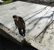 |
| JOHN
GASTALDO / Union-Tribun
Gary
Darnell walked on the foundation of what used to be
his home on Iron Springs Road in Harrison Park. Darnell
has a permit to rebuild his home, which was destroyed
in the Cedar fire, but the issue of questionable property
lines has come up.
|
HARRISON
PARK – When a firestorm burned through this tightly
packed mountain enclave, many people lost their homes and
belongings. Now many residents are finding they lost something
else as well.
They
discovered that what they thought was their land actually
may belong to their neighbor, and vice versa, because property
lines aren’t where people thought they were.
Rebuilding
in Harrison Park, where about 170 homes were destroyed by
the Cedar fire, is largely stalled as a result. Residents
say only one property owner has secured a building permit
and is ready to begin rebuilding.
Many
homeowners are faced with questions like this: Should they
build on their old foundation, even though part of their home
sits on what is technically their neighbor’s property?
Or should everyone agree to live with the boundaries that
had been informally recognized before the fire?
The
issue has caused much confusion and frustration in this quirky
community south of Julian, where cabins were crammed into
little nooks on winding roads off state Route 79.
Tonight,
the topic is expected to attract a crowd at a town hall meeting,
which county Supervisor Dianne Jacob will attend. The meeting
starts at 7 p.m.
An
aide to Jacob said yesterday the supervisor does not plan
to address the boundary issue at tonight’s meeting, because
it is so complex. Instead, Jacob plans to schedule another
meeting, probably for next week, at which property boundaries
will be the only topic on the agenda.
 |
|
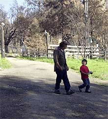
JOHN
GASTALDO / Union-Tribune
Gary
Darnell and his wife have guardianship of their grandson,
Jimmy Danieli (above), and they don’t want to spend
next winter in a trailer while they wait to rebuild
in Harrison Park. They lost their home to the Cedar
fire.
|
One
stymied Harrison Park resident who plans to be at the meeting
tonight is Gary Darnell. Darnell, a bus driver, lost his home
on Iron Springs Road and has a permit to rebuild. He and his
wife have guardianship of their 3-year-old grandson, and they
don’t want to spend another winter in a trailer.
“There’s
always been rumors and talk that your neighbor owns 20 feet
of your property and you own 20 of theirs,” Darnell said.
“We
always just let it go. Unless you have a survey done when
you’re purchasing, you just assume what you bought is
legitimate.”
Darnell
built a two-story addition to his home last year and the issue
of property lines never came up. It has now, because a property
owner down the road has questioned boundary lines, resulting
in a domino effect.
“The
majority, 99 percent of us, want to just accept what we had
before the fire and get on with the building. But you have
a couple that if the property can be adjusted 20, 30 feet
to their benefit, well. . . . ”
Paul
Kellogg lost three homes in Harrison Park. Kellogg shut down
his real estate business to concentrate on rebuilding.
Kellogg
said the county told him he couldn’t rebuild his garage
on Twin Oaks Lane because one-third of it would be on his
neighbor’s property. The garage had been there 25 years,
he said.
“They
wanted it set back three feet from the property line,”
Kellogg said.
“When
I bought the property 15 years ago, it was just like this.”
Kellogg’s
neighbor told him the garage was straddling their property
line, but nothing was ever done about it.
“Now
the county is coming along and saying I have no right to build
the garage there, and that’s not right,” Kellogg
said.
The
community’s roots – and its confusion about property
lines – date to the 1920s and R.E. “Rube” Harrison,
a landowner from Bonita.
Harrison,
who died in 1941, divided his land into 20-foot by 82-foot
parcels and sold them as camping spots for $10, according
to “History of San Diego County Land Surveying Experiences,”
a book by Curtis M. Brown and Michael J. Pallamary.
Eventually,
people built cabins on their property. For $5, they were able
to have their parcels monumented, which meant stakes were
put down to mark the boundaries. According to Curtis and Pallamary,
Harrison did not hire the best surveyor. His angles were off.
“The
northernmost parcels, as staked were about 40 feet off their
legal descriptions,” they wrote.
Bob
Adam, a Julian-area historian, summed it up like this: “You
have tent sites themselves that grew into homesites that were
not recorded properly due to bad legal descriptions.”
Harrison
Park residents “are a pretty cohesive group and yet they
are pretty independent,” Adam said.
“But
because of their independence, it has prevented them from
coming to adjudications. Unless you can get everyone to agree,
it’s not going to pass muster under law. Thus far, they
haven’t been able to to get total agreement.”
Reverting
to the pre-fire understanding of property lines would be the
best solution, said Teresa Manley, a director of the Julian-Cuyamaca
Community Resource Center.
“We
need to get everyone to agree to put the fences and borders
right back where they were and then go to binding arbitration
so that it can’t be reopened in the future,” Manley
wrote to county officials earlier this month.
“It
is going to be impossible to find one new survey that will
please everyone.”
In
an interview, Manley said some people were concerned that
if the boundaries were to be moved, it meant they had been
paying taxes for years on someone else’s property.
|